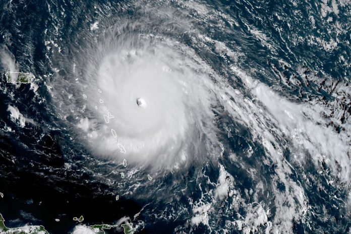
Hurricane Jose continued to meander off the coast on Saturday, spinning about 500 miles southeast of Cape Hatteras, North Carolina.
A sprawling high-pressure system over the central Atlantic Ocean is preventing Jose from heading out to sea, meaning it could pose a threat to parts of the East Coast through the coming week.
After weakening to a tropical storm on Thursday, Jose returned to Category 1 hurricane status Friday night. Its maximum sustained winds were 80 mph as of midday Saturday, according to the National Hurricane Center.
Under weak upper-level winds, Jose had made limited forward progress over the past week. However, over the next few days, the western edge of the high-pressure system that is trapping Jose is expected to weaken. This should create a path for escape.
The consensus track from the latest weather model updates now keeps Jose well off the Mid-Atlantic coast, with the storm likely to make its closest pass to the D.C. region Tuesday. At that point, Jose should be 100 miles or more east of Delaware, meaning that the local impact will mostly be limited to large ocean swells. Farther north, however, the storm could come closer to land.
Folks on Long Island and across coastal New England should keep increased attention to Jose as the week progresses. It is unclear what the intensity of Jose will be at that point – it may even be acting somewhat like a wintertime nor’easter by then. Regardless, the likelihood of impacts such as strong winds and at least minor storm surge is heightened.
Along with Jose, tropical storm action in the Atlantic remains extremely active. Tropical Storm Lee was named Saturday morning off the African coast, to the west of the Cape Verde Islands.
Out ahead of Lee, a potentially more ominous low-pressure disturbance is gathering steam. Likely to soon be christened Maria, this area of organized convection is showing signs of intensification. It is presently tracking due west toward the Lesser Antilles.
Unfortunately, conditions similar to those that allowed Hurricane Irma to intensify and track through parts of the island chain are still more or less in place. Current model projections are certainly concerning for a region still reeling.
The National Hurricane Center is forecasting a hurricane in the days ahead, and it is possible some places could take a second direct hit over the coming week.
Farther down the line, if a hurricane survives its trek near or through the Caribbean, the United States may have to watch this, as well.
(c) 2017, The Washington Post · Greg Porter
{Matzav.com}


Media creates these fears. Fake news. Nothing has happened. Nothing will happen.
They do expect Hurricane Jose to strike New York by the end of this week.
“…a potentially more ominous low-pressure disturbance is gathering steam. Likely to soon be *christened* Maria,…” Good English, poor Judaism. Find another synonym, like “dubbed,” and you’ll score well on all counts.