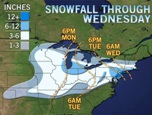
 New Jerseyans might not get a chance to rest after spending the weekend digging out from a major snowstorm. Forecasters say another storm has the potential for dumping heavy snow over the area.
The National Weather Service has issued a winter storm watch from Tuesday afternoon through Wednesday evening for Sussex, Warren, Morris, Hunterdon, Somerset, Middlesex, Monmouth, Mercer, Salem, Gloucester, Camden, Burlington, Ocean, Cumberland, Atlantic and Cape May counties.
Forecasters say low pressure moving from the Texas gulf coast tonight will head into the Ohio valley Tuesday. Forecasters say the storm will develop along the northern North Carolina coast late Tuesday.
Forecasters say the nor’easter could bring heavy snow to a good part of the Garden State through Wednesday.
{my9tv.com/Noam Amdurski-Matzav.com Newscenter}


Does Nor’easter mean that it is heading northeast, or that it’s coming from the northeast?
It means that the winds blow from the Northeast during the storm.
coming from the northeast
More precisely, strong winds blow in FROM the northeast, but the storm which creates the winds moves up the Atlantic coast FROM the south (usually from the Gulf of Mexico). As the storm rotates (much like a hurricane) in a counter-clockwise direction off the Atlantic coast, its leading winds rotate onto land from the northeast.
Whatever the word means, the fact is that this particular storm is currently to the south west of the northeaster seaboard (it stretches from northeast Texas through southwest Kentucky), and is moving in a northeast direction.
This storm looks as big as the last one, but the storm line is further north.