
 The potential exists for a major snowstorm to affect more than 50 million across the eastern United States at the end of the week.
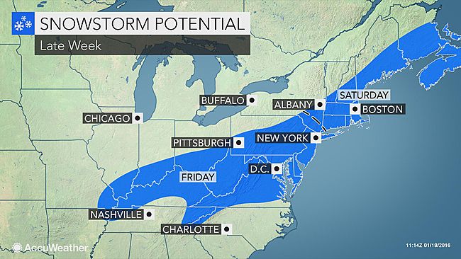
Areas from near Washington, D.C., to Philadelphia and around New York City are among other areas that could receive heavy snow from the storm.
The exact track of the storm will hold the key as to which areas in mid-Atlantic and New England are hit with heavy snow, dangerous highway travel and scores of flight delays and cancellations during Friday into Shabbos.
Unlike most storms so far this winter, this system will have sufficient enough cold air to produce snow and disruptions to daily activities in some areas of the East that have seen little thus far.
If the storm develops to its full potential and takes a track just off the mid-Atlantic and New England coasts, then a blizzard can unfold. The storm could shut down highways and perhaps cause airports to close.
This is the type of storm that is likely to produce a very heavy rate of snow.
In the swath of heaviest snow, motorists who venture out during the storm could become stranded.
Thunder and lightning could accompany the heavy snow in some coastal locations.
As the storm strengthens near the coast, winds will increase, and blowing and drifting snow will develop.
Along the mid-Atlantic and New England coast, a period of rough seas, minor coastal flooding and beach erosion can occur. The approaching full moon will cause high astronomical tides around the days where the storm will be near the coast, leading to heightened coastal concerns.
The storm will roll onshore in northern California to start the week, then dip southward toward the Gulf of Mexico at midweek, before turning northeastward along the Atlantic coast on Friday.
The wintry mix will ramp up over the southern Appalachians during Thursday night.
On Friday, the wintry part of storm will focus on the mid-Atlantic region.
Part of New England would be most affected by the storm from Friday night into Shabbos.
Based on the most likely storm track at this early stage, the swath from Washington, D.C., to Baltimore and Philadelphia, as well as the suburbs are included in the swath of heavy snow potential.
According to AccuWeather Senior Meteorologist Brett Anderson, “Should the storm continue northeastward, rather than turn more to the east at the last minute, New York City, Boston, Providence, Rhode Island, and Hartford, Connecticut, would also be buried in snow.”
Exactly how much snow accumulates will depend on the amount of, if any rain mixing in.
In either case, little to no snow would likely fall over northwestern Pennsylvania, upstate New York and northern New England, Anderson stated.
A wet or wintry mix scenario is most likely from northeastern North Carolina to southeastern Virginia, part of the Delmarva Peninsula and southern New Jersey.
Read more at ACCUWEATHER.
{Matzav.com Newscenter}


