 Severe storms are in the offing for the Northeast on Tuesday,bringing the threat of damaging winds and flooding downpours.
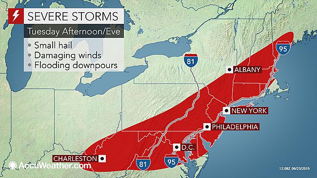
Millions of people from Maine to West Virginia should be on alert as a cold front swinging into the region sparks severe storms on Tuesday afternoon.
This includes a section of the I-95 corridor from near Boston through Washington, D.C., and the I-81 corridor from Scranton, Pennsylvania, to Harrisonburg, Virginia.
A dry and muggy morning will be followed up by a hot and humid afternoon on Tuesday, setting the stage for the development of severe weather. Some spots in eastern Virginia may even top out around the 100-degree mark before the storms blow through.
The first thunderstorms that develop on Tuesday are likely to be scattered over the region’s interior, but will quickly coalesce into a line and march eastward toward the Atlantic Coast through the evening hours.
“The biggest threats with these storms will be torrential rain and gusty winds in excess of 60 mph,” said AccuWeather Meteorologist Edward Vallee.
Vallee added that a tornado or two could occur with the strongest storms that track over eastern Pennsylvania and southern New England.
Flash flooding may also occur as these storms move though, especially following the soaking rain that Bill dumped on the region over the past weekend.
Severe or not, thunderstorms that roll through the Northeast on Tuesday will be accompanied by frequent lightning.
Drier, less humid air will filter into the Northeast for Wednesday in the wake of the storms and passage of the associated cold front.
This will bring more favorable conditions for outdoor activities such as golf, fishing or hiking on Wednesday afternoon when compared to Tuesday afternoon.
However, this break in the stormy weather is expected to be short as thunderstorms rattle the Northeast once again on Thursday and Friday. Read more at AccuWeather.
{Andy Heller-Matzav.com Newscenter}


